Property Boundary Survey
Property Boundary Surveys That Resolve Issues
Get a Free Quote From Us Today!
We aim to get back to you in 24 hours.
At Property Boundary Survey, we provide expert land measurement and mapping services to accurately define the perimeter of your land across the UK. This specialist service gives absolute clarity on property limits, whether you are planning a development or simply need to confirm your ownership for legal purposes.
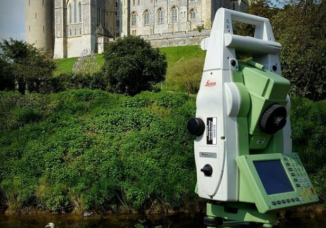
By using high-precision surveying tools, a property boundary survey ensures that physical boundaries match legal titles, helping to avoid costly disputes and protecting the long-term value of your estate.
What Services Are Included In A Property Boundary Survey?
A comprehensive package of technical and research-based tasks is included in a property boundary survey to ensure your boundaries are correctly identified:
- Title Deed Analysis – Reviewing official land registry documents establishes the legal baseline for all physical site measurements.
- High-Precision Site Capture – Using robotic total stations records the exact positions of all existing perimeter features like walls and fences.
- Boundary Marker Installation – Placing permanent pins or markers on the ground provides visible proof of your surveyed property limits.
- Dispute Resolution Support – Providing technical advice and expert evidence helps settle disagreements with neighbouring property owners.
- CAD Plan Production – Delivering a structured digital drawing shows the surveyed boundary lines relative to the national grid.
Why Should You Choose Professional Property Boundary Survey Services?
Choosing our professional property boundary survey ensures that your land data is accurate and technically sound for both legal and construction purposes. Qualified surveyors use regularly calibrated instrumentation that unvetted providers lack, which minimises the risk of building over boundaries or miscalculating land area.
This expert oversight maximises project efficiency, providing a clear audit trail and protecting your investment from the financial fallout of mapping errors.
How Much Does A Property Boundary Survey Cost?
The cost of a property boundary survey ranges from £400 to £3,500, depending on the acreage of the land, the complexity of the existing deeds, and the density of the terrain.
Pricing is primarily influenced by the time required on-site for data capture and the depth of historical research needed to reconcile conflicting title plans. Factors such as site accessibility and the requirement for certified RICS documentation for legal proceedings will also dictate the final professional fee for the survey.
Contact Property Boundary Survey to get customised prices for a property boundary survey at your property.
Get a Free No Obligation Quotation Today
Where Is A Property Boundary Survey Required Across Properties?
A professional property boundary survey is required for all types of residential, commercial, and agricultural assets where clear demarcation is necessary for legal or design purposes. This service is critical for developers building new housing and for owners of large rural estates who need to prevent land encroachment.
By mapping these locations, the service ensures that all structural extensions stay within the legal demise, protecting you from future demolition orders or costly injunctions resulting from incorrect positioning.
When Should You Carry Out A Property Boundary Survey?
You should carry out a property boundary survey before you exchange contracts on a property purchase or start any permanent construction work, like erecting a wall. Identifying potential boundary discrepancies early ensures that you do not inherit a legal liability or build over a neighbour's ownership line.
Engaging our team at the planning stage ensures your designs are based on fact, which prevents expensive litigation and keeps your project on a safe and predictable timeline.
How Does The Property Boundary Survey Process Work?
The process of a property boundary survey involves a systematic sequence of research, data capture, and meticulous drafting to guarantee geospatial accuracy. We begin by analysing your legal documents and then establish geodetic control points that provide a fixed reference for all site measurements.
This methodology ensures every marker is triangulated with absolute accuracy, resulting in a verifiable dataset that allows your legal team to draft accurate transfer deeds with total confidence in the land area.
What Information And Features Are Identified In A Property Boundary Survey?
Several critical elements are identified during a property boundary survey to provide you with a complete and indisputable record of your ownership:
- Perimeter Dimensions – Determining the exact geometric limits of the property facilitates accurate land registration.
- Physical Features – Documenting the location and type of all existing fences, walls, and hedges confirms current site conditions.
- Encroachment Zones – Pinpointing areas where neighbouring structures or eaves overlap into your legal land area helps identify breaches.
- Ordnance Survey Coordinates – Recording precise spatial data points geographically links the site to the national grid.
- Access Easements – Mapping the locations of shared driveways or public footpaths records rights of way for utility maintenance.
Request a free quote
Which Property Owners And Projects Require Property Boundary Surveys?
A wide range of stakeholders require a property boundary survey to manage the legal risks of land ownership, including homeowners and commercial developers. Solicitors and legal professionals use our data to resolve title disputes, while architects require precise limits to maximise building footprints.
For agricultural landowners, the service is essential for managing large estates and ensuring that all land transactions are based on verified and recorded data.
How Quickly Can A Property Boundary Survey Be Completed?
Technical work for a property boundary survey can typically be completed within one working day, with final digital plans delivered within three to five days. The speed of delivery is often influenced by the time required to reconcile physical measurements with complex historical deeds.
This efficiency ensures your conveyancing or construction schedule remains on track, providing you with the high-resolution plans needed to move forward without unnecessary administrative delays.
What Legal Standards And Regulations Apply To Property Boundary Surveys?
Every professional property boundary survey is conducted in strict accordance with the RICS Professional Statement for land measurement and current property law. Adhering to these standards ensures the delivery of reliable and legally compliant outputs that are technically sound for Land Registry applications.
Following these recognised industry codes provides the insurance-backed certainty that lenders demand, protecting the financial integrity of your property investment.
Contact Property Boundary Survey for a consultation to get a property boundary survey tailored to your organisation’s risks and responsibilities.
speak with our team today
What People are Saying About Us
★★★★★
"Fantastic property boundary survey service with accurate plans and excellent communication throughout the entire project."
David Harper
London
★★★★★
"The surveyors were professional, friendly and very knowledgeable. The final drawings were detailed and delivered quickly."
Laura Simmons
London
★★★★★
"Great experience from start to finish with fast turnaround times and clear boundary survey information provided throughout."
Thomas Reed
London
★★★★★
"Reliable company with excellent customer service and highly accurate survey plans that helped resolve our boundary concerns."
Amy Fletcher
London
Our Locations
We are proud to work nationally across the UK, allowing us to ensure we can provide services to you.
For a full list of counties we cover in the UK, see below.